Best Places to Visit in Matale
Matale occupies a significant place in Sri Lanka’s history and is situated in the Matale District, Central Province of the country. Matale is 142 kilometers from Colombo and lies closer to Kandy. The Knuckles Mountain Range which is a prominent feature surrounds the city. The British called the foothills Wiltshire. Matale is mainly famous for its agricultural products such as tea, rubber, spices and vegetables.
History
Matale has an illustrious history as is evident by the Aluvihare Rock Temple which lies in the north side of the city, where in 29 BC the Pali Canon was written down on Ola (Palm) leaves. In 1848 Matale was the center of a major battle between the Matale Rebellion and the British Garrison which was in the Fort McDowell was placed under serge. This battle was led by Veera Puran Appu and Gongalegoda Banda, who were addressed as National Heroes at that time. Monarawila Keppetipola Disawe was also another national hero whose home was Matale. He led the Uva Wellassa Rebellion against the British army. An icon of history, his ancestral home the Keppetipola Wallauwa still stands in its splendor in Hulangamuwa, Mathale.
Christ Church occupies a significant slot in the anal of historic Matale. This church was consecrated by Bishop James Champman in December 1860. Matale is the only sector that has a book written on its history which is called the Aithihasika Mathale, which in English is “Ancient Mathale.”
Weather in Matale
The climate in Matale is mainly referred to as tropical. The city experiences a significant rainfall each year and the annual average temperature is 25.3° C.
Tourist Attractions
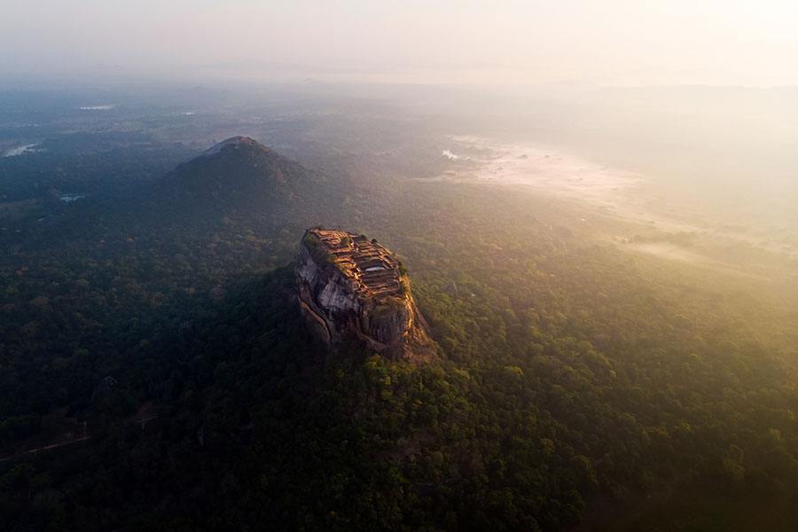
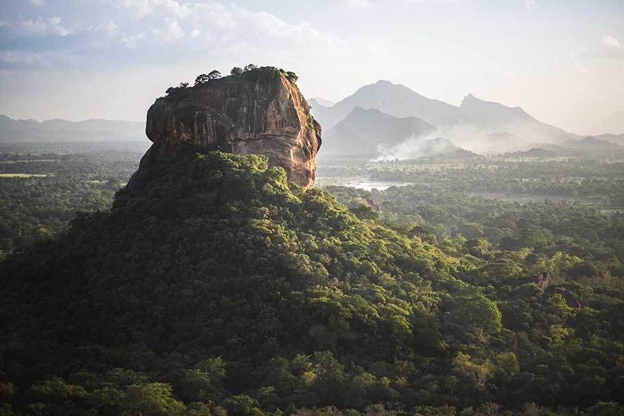
Matale is famous for the Sigiriya Rock Fortress which is of archeological significance to Sri Lanka and is nearly 200 meters high. The Pidurangala Rock Fortress is situated in close proximity to the Sigiriya Rock Fortress and lies close to Dambulla. It has a strong connection to the Sigiriya Rock Fortress. The Dambulla Cave Temple is also referred to as the Golden Temple of Dambulla and is a World Heritage Site and is the largest well-preserved cave temple in the country. Its height goes up to 160m.
Pitawala Pathana is unique in the arena of preserved grassland which is situated in the Knuckles Conservation Forest. The Wasgamuwa National Park is situated 225km away from Colombo. It was a park that was declared a haven for displaced wild animals, once the Mahaweli Development programme commenced. It was a nature reserve once but turned out to be a strict nature reserve later on.
The Riverstone Peak has a sheer drop of 300m and the Knuckles Mountain Range can be viewed in all its glory which is a stunning sight to behold. The peak has a peaceful atmosphere and the best place for meditation or just to relax. Sembuwatta Lake is a beautiful location and a tourist attraction. What is unique in Sembuwatte Lake is that it is man-made with natural spring water. It is believed to be 9m to 12m deep. Nalanda Gedige is an ancient stone temple and was constructed between the 8th and 10th centuries and adorns Dravidian Architecture, which had been used by the Buddhists.
Matale is indeed a vital part of Sri Lanka history and culture, with its historical heritage and is indeed a national treasure.
Make it to Matale the next time you are in Sri Lanka and feel the difference
Are you planning to Visit Matale?
Check out the places we recommend you to visit on your trip to Matale
Sigiriya Rock Fortress
Sigiriya is an ancient part of Sri Lanka’s heritage and historic past. Its other name is the Lion Rock and is located in the Northern Matale district in the Central Province of Sri Lanka. According to the Culavamsa, King Kashyapa (477 – 495 CE) selected the site as his new capital. The King built the palace atop the rock and went ahead and decorated its side with beautiful frescoes. An enormous lion was built on a plateau alongside this rock, which depicts a gateway; hence the name Lion Rock. When the King died the capital and this rock was deserted and was used as a Buddhist Monastery until about the 14th century. Today this historical rock Sigiriya has been designated a UNESCO listed World Heritage Site. It has to its credit as being one of the best examples of earliest town planning. A formation from a lava plug of volcano debris, Sigiriya has come to be a respected and much visited place by local and foreign visitors.
Mythological Past
Sigiriya has many stories behind its illustrious beginnings. Archeologists describe as a post-historical archeology turning point of Ravana. They point out that Sigiriya may be called the City of Gods that was constructed about 50 centuries ago by King Kubera who was the step-brother of Ravana. This is described in the Ramayanaya.
Historical archives in the Palm Leaf Book (Puskola Potha) say that Maya Davana was the architect of Sigiriya. Davana built Sigiriya on the instructions of King Visthavasa, who was the father of Ravana. Sigiriya in the past was called Chithranakuta. The Palm Leaf Book also states that King Kashyapa selected this spot for his palace due to the fact that his mother was a staunch follower of the Yakka belief. She was also a descendent from them. The wall paintings that have gained recognition worldwide can be said to display about the Sinhalese land. The Palm Leaf Book goes on to describe the blue coloured lady as the Yakka Tribe and the other damsels represent the tribes of Naga (Serpentine), Deva (Divine), and Gandabhbha (Celestial Musicians) and the flowers depict the unity that prevailed in the country.
Historical Past
Sigiriya has an illustrious historical past and is one of Sri Lanka’s most preserved historical sites. Sigiriya was used as a Monastery since the 3rd century and after a period of 8 centuries, it was transformed into a royal palace. The Fortress of Sigiriya in early history is connected to several catastrophic events between two royal brothers, namely Kashyapa and Mugalan, where in the ultimatum Kashyapa forcibly took the throne. This prompted Mugalan who was the legal heir to the throne to flee to India as he feared that his brother Kashyapa would attack him. Kashyapa then constructed the royal palace upon a plateau rock in a bid to drive off the right heir of the throne, Mugalan.
The Mirror Wall
This unique parapet wall was built 1600 years ago. It is a plastered brick parapet wall with an inner passage that counts 2 meters. The Mirror Wall is a stretch of polished marble slabs which adorned the walkway. It is said that the wall was so polished that when King Kashyapa walked passed it, he could have seen his reflection perfectly.
Sigiriya Location on the Map
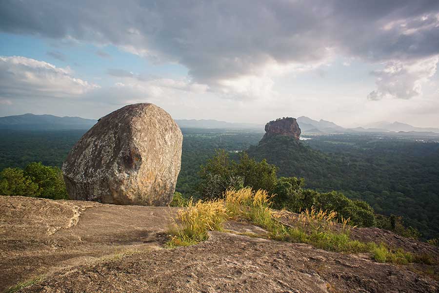
Pidurangala Rock
Pidurangala is a huge rock formation that is situated a few miles off Sigiriya in the Matale District, Central Province of Sri Lanka. Similar to the formation of Sigiriya, Pidurangala is also a part of lava plug from a volcano. Although much larger than Sigiriya, Pidurangala its top surface is steeply sloped and is of hard rock, than Sigiriya. Hence, it was not a suitable place for large building activities. Paintings very much likely to the paintings in closer areas of historical interest and statues can be seen at this beautiful place.
Pidurangala Rock Temple
A few remains show the last survival of the Royal Cave Temple. There is a rock wall foundation which still shows that there once existed the Rock Cave Temple. This ancient temple and forest monastery is said to have been built by King Kashyapa when he commenced building the Rock Fortress of Sigiriya. The Temple consists of a plethora of ruins and the “Image House” which is sheltered within the rock has two chambers. The deeper chamber contains The Inner Chamber contains various Buddha Statues. The journey to the caves is by ascending the summit via an ancient stairway and through a small coppice woodland where a 14.6 metres length statute of a reclining Buddha is located.
It is said that the maiden frescoes illustrated on Sigiriya rock fortress that face Pidurangala and bearing lotus flowers were for worshipping Lord Buddha at the Pidurangala Temple and Monastery.
Apart from the rock being a climbable one, the Pindurangala Rock Temple was a haven for meditation of Buddhist clergy. The hill is inundated with caves and tiny cells, which were supposed to be used by the Buddhist clergy for meditating. Monks even today, meditate in this tiny cells. History says, that King Kashyapa transported the monks to Pidurangala from Sigiriya when he started renovations of the latter’s site.
One could witness a blanket of green which is the forest canopy and vegetation that is spread below, whose view is breath taking no doubt. A long cave to the east of the summit has been divided into three sections by walls. Adjoining this cave is a 7th century rock inscription, which says about donations of gold and fields. It is said that the name Pidurangala in Sinhala means “offered gold.” It is said that King Kashyapa had turned out a golden lotus from all his jewelry and donated it to the monks who lived there at the time. This was before he left to battle his brother Mugalan. It was at this battle that King Kashyapa took his own life.
As the access to this area is easier than Sigiriya, no doubt this is why King Kasayapa did not want his palace built here and chose Sigiriya instead.
Wildlife
Surprised? Yes, Pidurangala Rock Temple does have its own wildlife around it. The brilliantly colored lizards and water snakes in their camouflage are an attraction at the Rock. The call of the birds from the surrounding forests serenely invades the beautiful stillness of Pidurangala.
Pidurangala Location on the Map
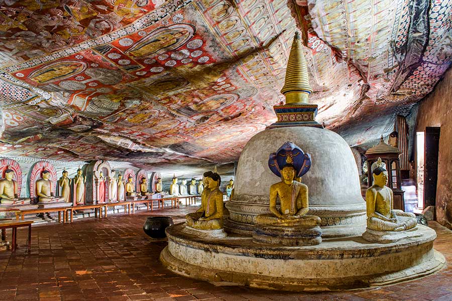
Dambulla Cave Temple
Dambulla Cave Temple is also known as the Golden Cave of Dambulla, was declared a World Heritage Site in 1991. The Temple Complex goes back to the 1st century BC and boasts of give caves that are embedded under an overhanging rock, which has a drip line to keep the water from seeping through. The Dambulla Cave Temple has images of the Lord Buddha and Bodhisattvas. The Temple is preserved well and is still held in high esteem as the oldest edifice in the history of Sri Lanka. This beautiful icon of historical elegance dates from the second and third centuries BC. Even at that time, it boasted of being the largest and important monasteries in the country.
King Valagamba of Anuradhapura (Wattagamani Abhaya) is customarily supposed to have transformed the caves into a temple in the first century BC. Banished from Anuradhapura, he pursued refuge here from South Indian usurpers for 15 years. After he reclaimed his capital, the King constructed a temple in thanksgiving. Kings who followed him later added to it and by the 11th century, the caves had become a major religious center and still continue to be. Nissanka Malla of Polonnaruwa gold-plated the caves and included around 70 Buddha statues in 1190. The Kingdom of Kandy restored the caves and had them painted during the 18th century.
The 5 Caves
The Temple consists of 5 caves of total splendor and beauty. The caves were constructed at the foot of the 150m rock during the Anuradhapura and Polonnaruwa eras and carry an aura of elegance, in that they are definitely the best from the many caves found in Sri Lanka. These caves can be accessed along the sloping Dambulla Rock which also gives a beautiful view of the surrounding forestry and scenery, where the Sigiriya Rock Fortress is also visible. The largest of these 5 caves measure 52m from the east to the west and 23m from the entrance to the back. This remarkable cave is 7m tall. Statues of Hindu Gods are seen hear and so are Valagamba and Nissankamalla including Ananda, a trusted disciple of Lord Buddha. Out of these 5 caves, the following are the most significant.
Cave of the Divine King
The Devaraja Lena (the Sinhalese word for cave is “lena”) is the first cave. The entrance of the cave has an account of the founding of the monastery which is depicted in a 1st century Brahmin inscription. This case has a 14 m statue of Lord Buddha which is carved out of a rock and has been painted many times to preserve its beauty and heritage. At the Lord Buddha’s feet is Ananda and at the Head of Lord Buddha is Vishnu who is supposed to have used his divine powers to create the caves.
Cave of the Great Kings
The second biggest cave has 40 seated statues of Lord Buddha along with the 16 standing statues. Accompanying these statues are the Gods Saman and Vishnu, where devotees places garlands of flowers and then the statues of King Vattagamani Abhaya, who reverenced the monastery in the 1st century BC and the King who was responsible for gold plating 50 statues, Nissankamalla, which is indicated in the stone inscription at the entrance to the monastery.
The cave is aptly called Maharaja Lena which is meant “Cave of the Great Kings.” The statue of Lord Buddha which has been carved out of the rock on the left side of the room is accompanied by wood figures of the Bodhisattva Maitreya, Avalokiteshvara and Natha. There is a spring which has a constant drip of water and said to be having healing powers. This drip of water seeps through a crack in the ceiling. The Lord Buddha’s life is depicted in tempera paintings upon the cave ceiling which dates back to the 18th century. This has a direct connection to the dream of Mahamaya to Mara (demon) temptation.
Dambulla Cave Temple Location on the Map
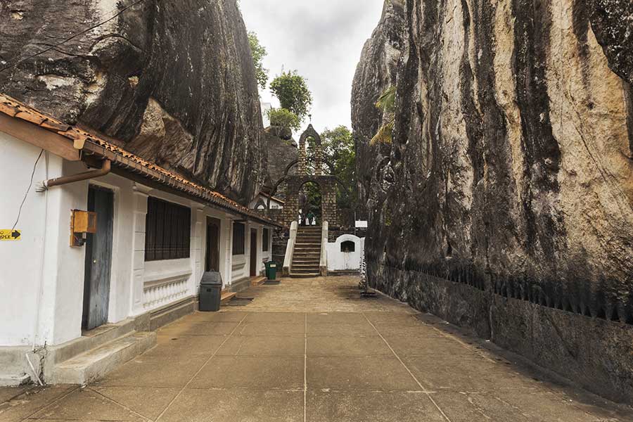
Aluvihare Rock Temple
The Aluvihare Rock Temple also known as the Matale Alu Viharaya is a Buddhist temple located in Aluvihare, Matale District, in the Central Province of Sri Lanka. Its vicinity is surrounded by hills and the temple is located 30km north of Kandy. The temple’s history can be traced back to the 3rd century BC up to the reign of King Devanampiya Tissa. It is believed that after the introduction of Buddhism to the country during his tenure as King, he built the dagoba, planted the Bo-sapling and founded the temple.
History and Importance
It was during the period 100-89 Century BC when King Valagamba reigned, Sri Lanka faced a famine which was named “Baminithiyasaya” for a period of 12 years. To add to this there was a South Indian invasion and the monks of that era realized that there was a danger to the Buddha Sasana in Sri Lanka. The monks went through a hard time during this period and for them it was difficult to memorize the Tripitaka (doctrines of Buddhism) as the conditions were not apt for same. They moved to the hilly areas and lived on the banks of the Mahaweli River under conditions that were deteriorating by the day. After 12 years the famine came to an end and the monks returned to Anuradhapura with the idea of translating the Tripitaka. The monks then decided on carrying out this significant event at the Aluvihare Rock Temple.
It is said that 500 monks gathered at the Aluvihare Rock Temple to carry out this task. The entire transcription was carried out on Ola Leaves (Puskola Poth). However, these well preserved Ola Leaves were totally destroyed in the Matale Rebellion in 1848. Aluvihare Rock Temple is inundated with many caves with earliest writings. The main cave has an impressive statute of the reclining Lord Buddha, accompanied by standing and sitting images.
How Aluvihara got its name
The name “Aluvihara” has a plethora of meanings and legends tied up to it. The original name was “Alu-Lena” or “Aloka-Lena” which in English is known as “Luminous Cave.” When King Devanampiyatissa reigned, a monk worked on the commentaries. The King of Devas, Sakra having seen that it was difficult for the monk to carry out this task, illuminated the cave so that the monk could carry out his task with ease. The cave temple faced east and because of this each morning the rays of sunlight filtered through the cave. This was one reason that the cave was termed “Aloka-Lena.”
If one looks at the names that were given to this hallowed Temple it all concludes with the belief that the temple has a direct connection to light.
Aluvihare Rock Temple Location on the Map
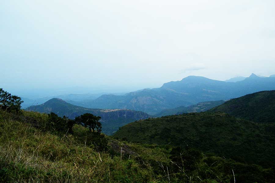
Knuckles Mountain Range
The Knuckles Mountain Range is situated in the Central Province of Sri Lanka in the Matale District. The name takes after a series of recurrent folds and peaks in the mountain range which depicts a clenched fist with its knuckles protruding. Hence the name Knuckles Mountain Range. The Knuckles Mountain Range got its name from the British, but the Sinhalese people of today call it the Dumbara Kandu Wetiya which means Mist-Laden Mountain Range. The top of the mountain range has a thick layer of clouds that cascades covering the peaks, at times.
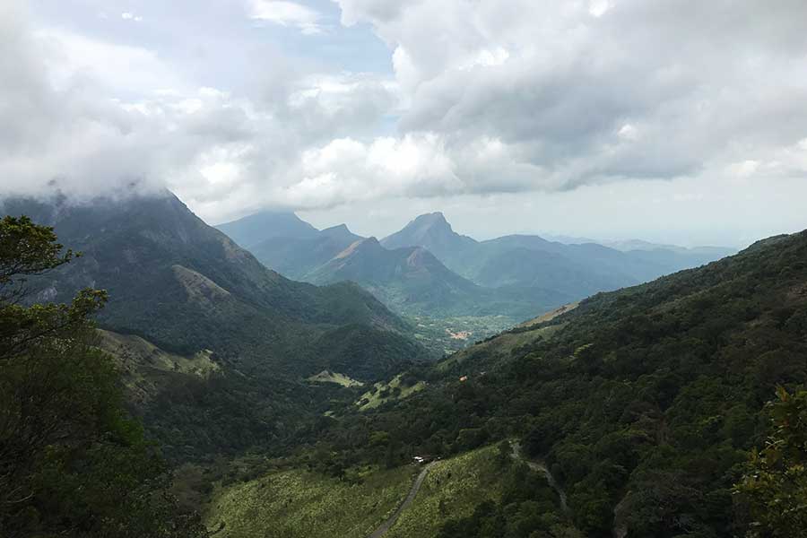
It occupies a slot as one of Sri Lanka’s most attractive and eye-catching nature attractions. It’s no doubt a trekker’s dream come true, with ever changing terrain of prairies, rough mountain peaks, intermingled with streams of crystal clear water and waterfalls that cascade down resembling a bride’s train, flowing serenely behind her. Being a World’s Heritage Conservation area that gives trekkers new possibilities each time, still has a virgin beauty and serenity about it. The popular hiking trails are best approached from Deanstone; trekking could trail to Dothalugala from Deanstone; Trail to Nitro Caves from Corbett’s Gap; Ahugallena cave via Thangappuwa from Corbett’s Gap; Kalupahana from “Meemure” Village.
The Mountain Range is within the same geological origins of Horton Plains and Peak Wilderness Sanctuary but stand apart from these two historic components of Sri Lanka’s heritage. The highest peak in the mountain range is 1094m. The Knuckles conservation forest has a natural vegetation of trees that resemble pigmies and reach up to one’s waist. Along with Horton Plains and Peak Wilderness Sanctuary, Knuckles still enjoys the pristine vegetation grasslands.
Mini World’s End at Knuckles Range
A fine point for observation of the beautiful scenery around is from Mini World’s End (1992m). From this terrain, one could witness an impressive panoramic view of the mountain range and villages that dot the base of Knuckles.
Weather and Climate
The weather is unpredictable and could change within a matter of seconds or minutes. A blanket of thick mist envelopes the mountain in seconds. It could rain anytime. The temperature ranges from 5.5 degrees to 35 degrees Celcius. Gaps in the mountain range provide a pathway for the Southwest monsoons. Trekkers need to carry with them light raincoats and caps, as at times the weather is not predictable over the mountain range.
Forests
The Knuckles is a haven for a variety of forests, with its crystal clear waterfalls, and nature enthusiasts would no doubt be enthralled by what these forests have to offer. The lush tea plantations dotted by small villages adds color to the beauty of nature that lies around this historic mountain range.
Waterfall Trekking
Waterfall Trekking! Sounds like an adventure! And yes it is an adventure of sorts. Trekking waterfalls is considered the most adventurous part of your visit to the Knuckles Mountain Range. Hidden among the hills, the breathtaking waterfalls flow silently at a synchronized rhythm on a low keep volume. Hurting no one, but showing off the talents that nature has to offer. A beautiful sight, the Knuckles Mountain Range is home for a plethora of beautiful waterfalls hidden inside the canopy of lush greenery and sheer rocks.
Knuckles Mountain Range Location on the Map
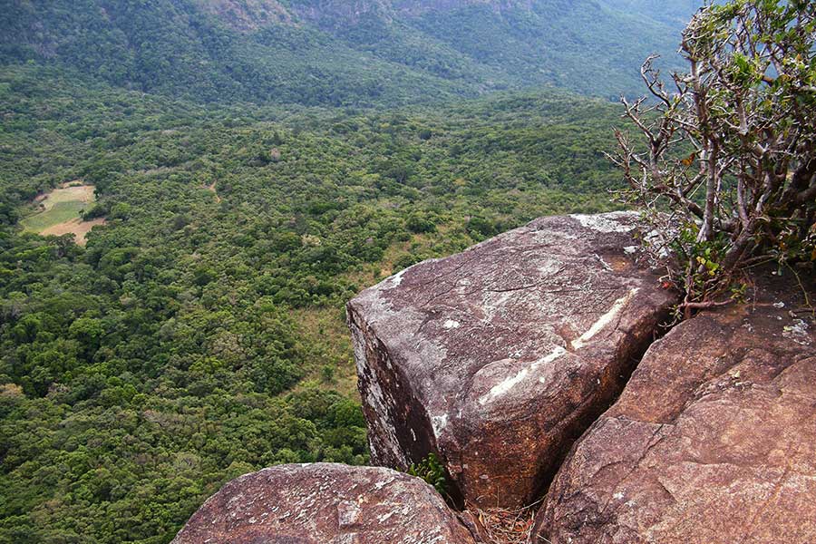
Riverstone
Riverstone is located 30km from the Matale Town. The hair-raising windy road with its hairpin bends, but definitely a safe road, gives travelers a new experience and offers some of the best views of the surrounding country side, so much that it is called Mini World’s End. The climate here is in par with Horton Plains, where World’s end is located. Riverstone is laced with two beautiful waterfalls “Sera Ella” and “Bambarakiri Ella.” A unique feature at Sera Ella is that it has rock seats where visitors can sit and enjoy the spray of the waterfall and droplets of water that splashes around. The Thelgamu Oya, is a freshwater river and a refreshing finish to a hard days trekking.
The trek is two and a half kilometers one way and trekkers would not doubt enjoy a healthy hour of trekking. The trek runs alongside the Pitawala Pathana, which leads to Riverstone Peak. The countryside is dotted with paddy fields, which no doubt trekkers might find astonishing, but this is a unique feature in mountainous regions worldwide. The beautiful lush Central Highlands can also be seen on this trek.
A sheer drop of 300m is a key feature of Riverston Peak, where one could view the Knuckles Mountain Range and Thelgamu River (Oya) valley. A peaceful atmosphere prevails giving more projection to the beautiful surroundings and for those who wish to meditate, this is the place of serenity. Photographers can take their picks in many a click on the Riverston trek, which is a haven for nature lovers as well.
Matale is indeed a place to visit in Sri Lanka and needs to be added to bucket lists. The beauty of Riverston which is a part of Matale and its lush breathtaking mountain ranges that surround the city, as it trying to protect it, is a must visit place. A part of Knuckles Mountain Range, Riverston Peak is a beauty of mother nature’s gift to the Matale District.
Bambarakiri Ella Falls
Bambarakiri Ella Falls or Bambarakelle Waterfalls is one of the tallest waterfalls in Sri Lanka. Its sheer drop is breathtaking and today it occupies a slot as the 299th tallest waterfall in the world. Its beauty is breathtaking, but one needs to be mindful of the slippery slopes around and taking precautions by wearing rubber soled footwear is a must. Travelers come face to face with Mother Nature and her beautiful “turnout” of cascading water in a sheet resembling a bridal veil as it roars down at a steady speed, keeping travelers in awe. There is a rock pool at the base of the waterfall, which is safe for a luxurious dip during summer, but definitely not otherwise. If you dare to take a look from the top of the waterfall, travelers will be in awe of the beautiful natural landscapes around, which has been the work of mother-nature.
Riverstone Location on the Map
Pitawala Pathana
The Knuckles Mountain Range has a lot to offer with its scenic beauty the misty range but if it is not possible to cover all these beautiful sites, it is best to settle for Pitawala Pathana, which is a cast grassland and a mini forest which spans across the Knuckles Range. It can be visited in a day, but if one really wants to take in the beauty of this place, a day or two would suffice.
Pitawala is exclusive grassland of “Pathana” type found in the Knuckles Mountain Range. This Pathana is of ecological value. The grassland in Pitawala Pathana covers around ten hectares of a sloping slab of rock which is veiled with a thin layer of soil. The turfgrass has a velvet effect. Many isolated trees could be found in this area. It is not any forest of grassland it is a unique one found in the Matale District.
An area worth examining is the ecosystem of the undergrowth at Pitawala Pathana. Visitors will be amazed at the amphibians, small mammals, lizards, tree frogs and a few endemic plants. It is a haven for small plants as these are the only plants that can survive in the extremely strong winds. Matale has a lot to offer with its breathtaking scenic view of pine forests, tea estates, paddy fields and endless mountain peaks. The open stretch of the countryside moves away at the mini World’s End comes into view with a sheer cliff drop which along with a magnificent view gives a spine tingling moment. The winds are pretty strong and visitors are advised to watch their step and refrain from trying the dangerous.
Mini World’s End is a deep escarpment that is situated in Pitawala Pathana and a part of the Knuckles Mountain Range. This location can be accessed by the designated nature trail across Pitawala Pathana and is around 750 m away from the main road.
Riverstone Location on the Map
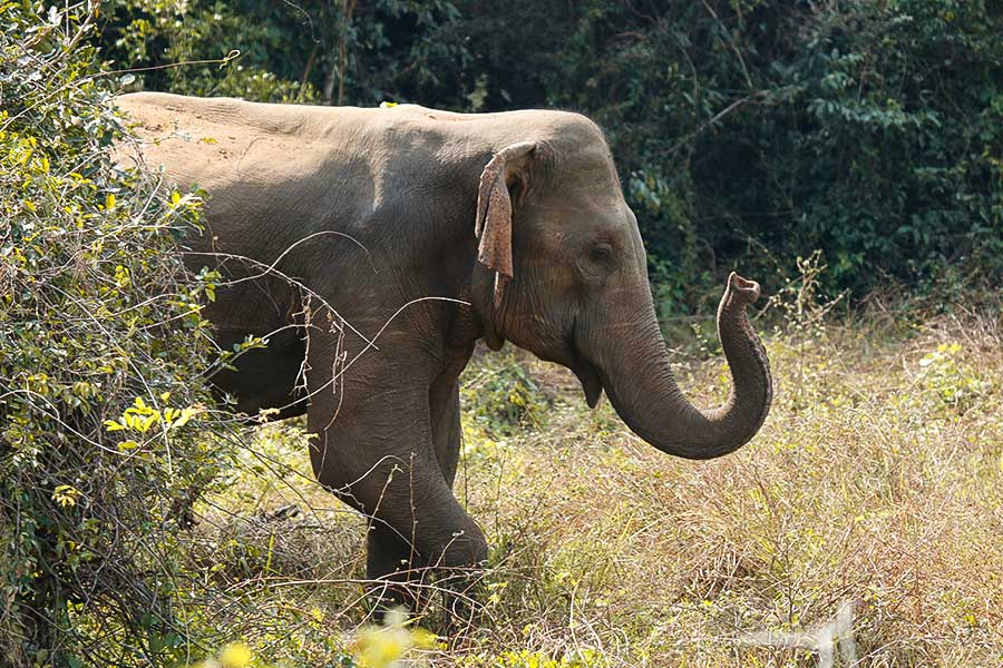
Wasgamuwa National Park
The Wasgamuwa National Park is a natural park which is located in the Matale and Polonnaruwa Districts. This park was made out to protect wild animals during the Mahaweli Development era. In 1938 the park was terms a nature reserve and it went on to be regarded in the early 1970s as a strict nature reserve. Wasgamuwa is a highly protected area for wild elephants. The name Wasgamuwa was conjured from the name “Walas Gamuwa”. “Walas” is the Sinhala meaning for “Sloth Bear” and Gamuwa is terms as “Wood”.
History
The tanks Malagamuwa, Wilmitiya, Dasthota and Kalinga, which were used for irrigation and the Yoda Ela (CanaL was built by King Parakramabahu I. These tanks and canal still remain within the precincts of this national park. Irrigation systems existed in the past as well and water was irrigated from the Minipe Anicut left bank canal to Parakrama Samudra via the Amban River which in those days ran through Walasgamuwa.
Fauna
Wasgamuwa National Park is the residence for a wide range of species of mammals. The park is inhabited by around 150 Sri Lankan Elephants. The Purple-faced Langur and the Toque Macaque are monkeys found in the park and are endemic to Sri Lanka. The Water Buffalo and Chital (Axis Deer) are common to spot. However, the Sri Lanka Leopard and Sloth Bear are uncommon animals and live more in the interior.
There are 143 bird species residing within the park with a selection of reptiles as well. The bird species range from Red-faced Malkoha to the common Sri Lanka Junglefowl.
Flora
Wasgamuwa National Park boasts of the top most biodiversity which lies in the protected areas in Sri Lanka. There are more than 160 floral species that have been recorded from the park. Wasgamuwa National Park exhibits one of the highest biodiversity among the protected areas in Sri Lanka. Two plants with economic value are the Cryptocoryne Walkeri and the Munronia Pumila. The reservoirs and river forests have a large number of fauna species. These forests have several layers. A tree of significance among all these trees is the 1700 years old Tamarind tree, “Oru Bendi Siyambalawa,” was situated in this park.
Sri Lanka has a plethora of beauty within the avenues of history of the country. Its cultural heritage is something that the country is proud of and keeps protecting all the time.
Wasgamuwa National Park Location on the Map
Sembuwatta Lake
Sembuwatta Lake is a man-made lake but still has a hidden beauty as it nestles in the midst of the Elkaduwa Plantation in the Matale District. With its depth of 30-40 meters Sembuwatta Lake is filled with natural spring water. It’s best to take in its beauty and not decide to take a dip in it. Visitors are advices to refrain from taking a dip no matter how tempting the beauty of this lake is. To cure the thirst of visitors wanting to take that dip, a pool has been built alongside the lake where visitors can indulge in a swim, which is safe.
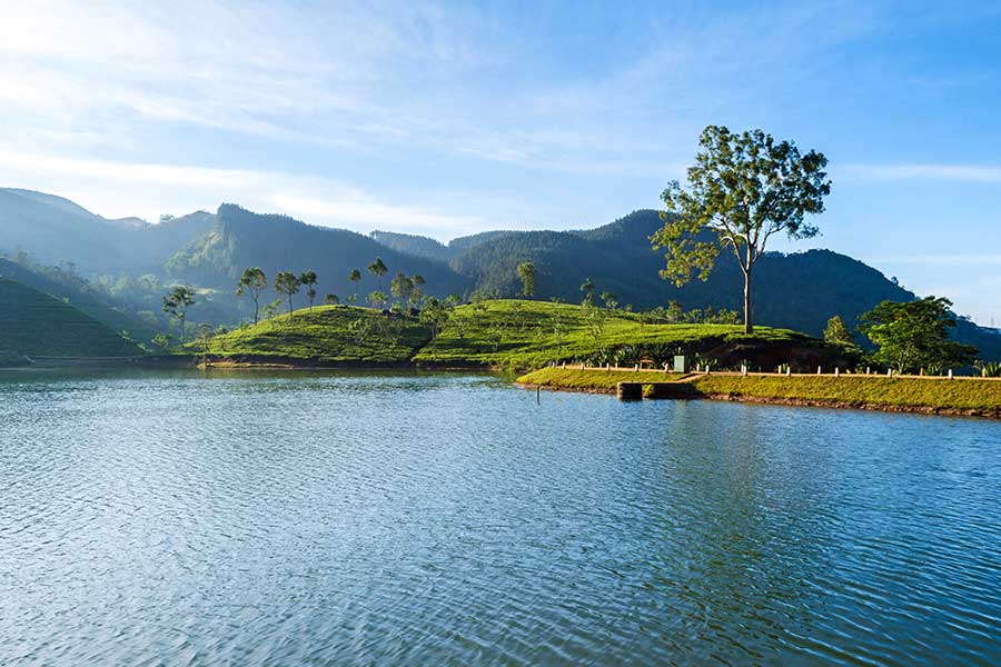
The scenic beauty of the lake creates a picture in the minds of visitors that cannot be erased. The lake is atop a hill and can be reached by a vehicle or if there is that adventurous streak in tourists then a trek or hike would be ideal. The Elkaduwa Estate maintains the Sembuwatta Lake and travelers are supposed to obtain an entrance ticket for the lake which is available at the entrance to the tea factory. The distance from the entrance to the lake is 2 kilometers. The Sembuwatta Lake was initially a gold course which was used by the British, but later on, they turned it into a lake. The lake originated from natural spring water.
The lake does not have shops or restaurants around it and visitors are advised to carry their own food and water. A bit of advice to visitors is that once they partake of their meals, all litter should be taken back with them. The lake is explicitly clean and the authorities do not tolerate litter being thrown around.
Sri Lanka is famous for its natural lakes and waterfalls. Sembuwatte although man-made has a base of naturalness within it.
Sembuwatta Lake Location on the Map
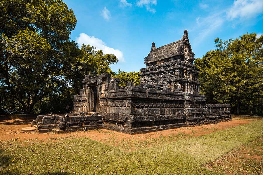
Nalanda Gedige
Nalanda Gedige is an ancient stone temple in the Matale District, which was built between the 8th and 10th centuries. The architecture is Dravidian and this temple is supposed to have been used by the Buddhists in the area. Nalanda Gedige takes the form of a Hindu temple. The temple is however affiliated to Hinduism.
History
The temple was built 1000 years ago. The temple has a curious hybrid of Buddhist and Hindu architecture, which no doubt would have been sparked by the total unrest that engulfed the country in the era gone by and the South Indian Kings establishing themselves in the wake of this turmoil. It is a distinct feature that some of the architecture is definitely related to the Hindu religion. However, still, there are no statues of Hindu Gods, which is indeed a curious thing.
Architecture
Nalanda Gedige was planned in the standard system of a Hindu haven; with a mandapas or lobbies utilized for special events, a passageway section which was initially roofed, a primary focal place of worship, and an ambulatory around this holy center. The picture is very opposing however as there has been no indication of Hindu Gods found inside the temple, and there were uncharacteristic components not found in a standard South Indian style Hindu temple.
For instance, the lavishly adorned exterior segments is accepted to be of South Indian structure from the period of the Cholas and Pandyas; yet the presence of the lord of riches, Kubera, situated on a lotus pedestal in a semi-rounded area on the southern segment, is a component that is found only in Sri Lanka. There are additionally dissolved Tantric Buddhist carvings of a sensual tone, much like the popular ones at Khajuraho in India.
Named after the unsurpassed Buddhist University at Nalanda in India, it has been said that Nalanda Gedige is “one of those blessed spots that have no history.” The astounding absence of learning with respect to this holy place, and why it was situated at Nalanda foils the individuals who wish to dig into its past. Indeed, even gauges of its date of development differ from the seventh to eleventh hundreds of years AD. This was a time of incredible unrest on the island, with South Indian lords setting up themselves in the wake of the decay of the Sinhalese government. It is conceivable that Nalanda Gedige was a strong endeavor at a combination of Tamil and Sinhalese societies.
The Edifice Today
The Nalanda Gedige is an archeological site that is synonymous with Sri Lanka’s heritage and is shrouded by a canvas of mystery that surrounds its very existence. The fact that it depicts Hindu architecture, but at the same time does not have any statues of Hindu gods, is something of a mystery.
Nalanda Gedige Location on the Map
Other important tourist places that you can visit along with Matale
Sera Ella falls at Riverstone
Kadiyanlena Falls
Meemure
Lakegala Mountain
Thelgamu Oya
Wedda Peni Ella
Manigala