Best Places to Visit in Badulla
Badulla is the southeast border of central hills in the upcountry which is the transport portal to the east coast. One of the oldest towns of Sri Lanka invaded by Portuguese and British consequently became one of their main economic hubs. British invasion caused conspicuous changes to the city, more significantly it was an important Social Centre for them.

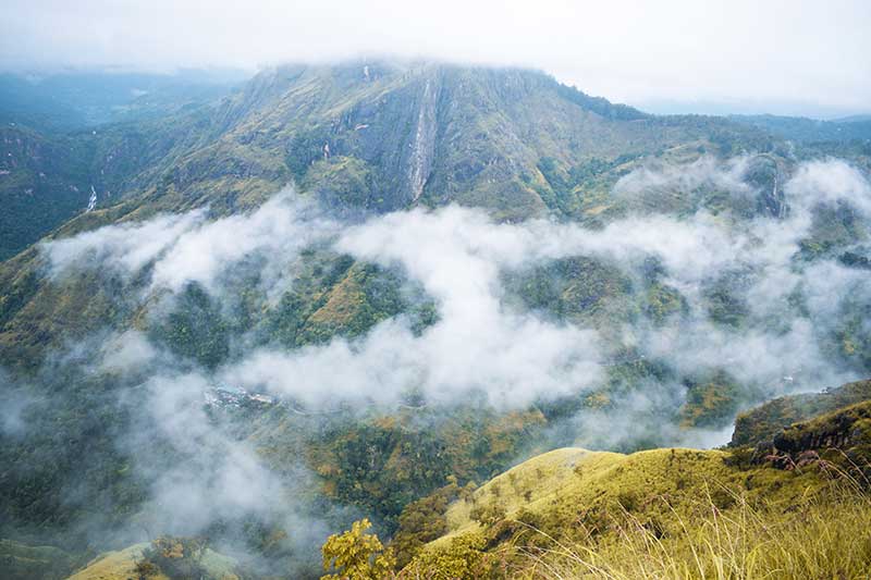
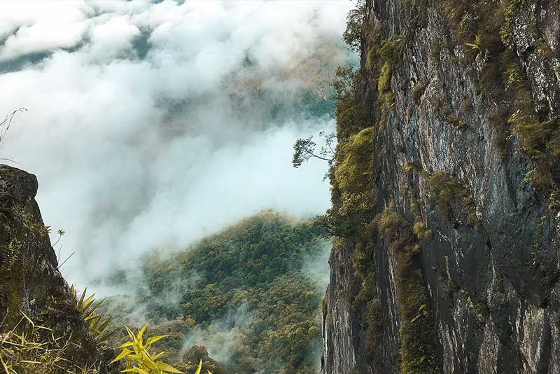
Will you enjoy a relaxing evening in the countryside and observe the outstanding biodiversity of the area? Cool-weather conditions throughout the morning and night encircle by mist and fog is an incredible experience staying in a tropical country. Beautiful rainy weather conditions all along the day together with freezing nights make it unique from other Sri Lankan cities. Beyond its conspicuous natural beauty, you can arrange an adventurous hiking trail to a spectacular mountain top. A journey to embrace the extraordinary elegance of the naturally enriched Flora and fauna.
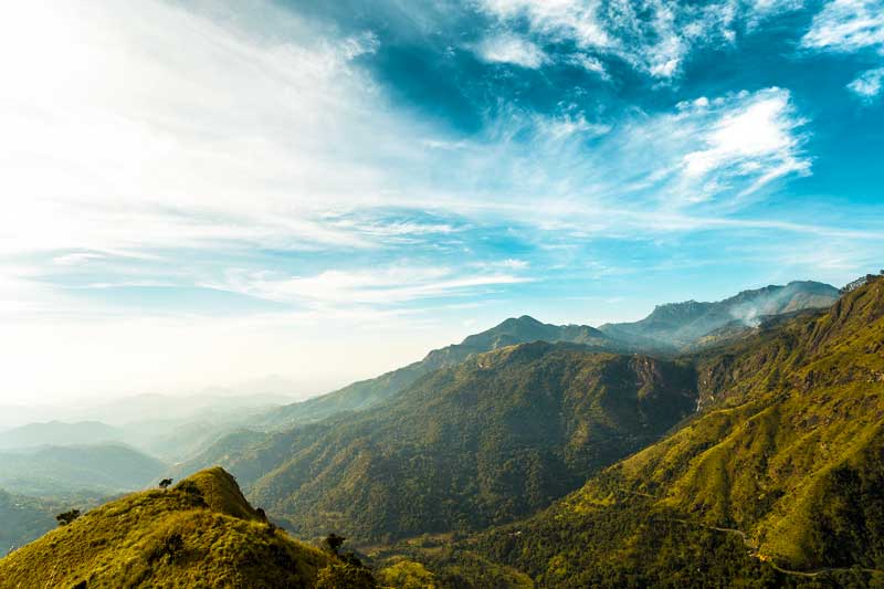
Badulla is the capital city of the Uva province which is almost begirt with Badulu Oye River. Situating 680 meters (2,230 ft) above the sea level, surrounded by copious tea plantations. The Namunukula mountain range together with fellow mountains overwhelmed the town creating an enchanting view for visitors.
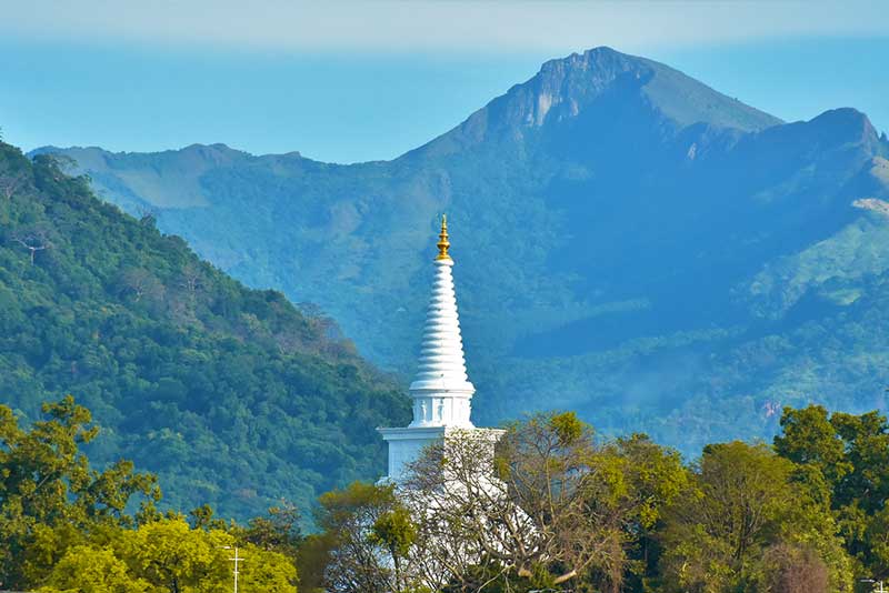
It’s highly recommended for eco-tourism for the betterment of tourism as well as the definite development of the locality. Badulla is a prime location in Sri Lankan tourism for decades. The popular Nine Arches Bridge has an immense magnetism among both local and foreign visitors. Ella Rock, Little Adams Peak, Diyaluma Waterfalls, Mahiyangana Viharaya, Sorabora Wewa, and Ellawala waterfall annually attract a higher percentage of tourists who come to Sri Lanka.
Weather in Badulla
Usually, Badulla has a slightly lesser temperature compared to the other cities in Sri Lanka. The average temperature typically varies between 16°C to 30°C (61°F to 86°F), rarely it become below 13°C (56°F) and above 33°C (92°F).
Usually, April is the hottest month of the year while November to January becomes the coldest. It has extremely variated accumulations in rainfall throughout the year. The highest rainfall records around November while the least is around July.
Are you planning to Visit Badulla?
There are adventurous hiking trails and different other places to visit in the Badulla District. You will be able to easily find board and lodging in Badulla since there are many hotels that will fit into your budget.
Check out the places we recommend you to visit on your trip to Badulla.
Ella Rock
It is the most famous place in Badulla which is a hiking trail near the Ella station that will lead you to the peak of Ella Rock. Journey through the footpath to the Ella rock will never make you tired even though it feels like a long way to reach the top.
Visit Colombo Fort and jump on a train to begin the exciting journey to witness the amazing Ella Rock. Situated in the Badulla District in an elevation of 1041 meters above sea level Ella is one of the best travel destinations for everyone. The journey provides you the opportunity to witness the country roads in Sri Lanka enriched with a variety of fauna and flora.
The best part of the Journey to Ella Rock Hike begins from Kandy to Ella Railway Station. It provides visitors with a unique experience to enjoy the rich biodiversity along the railway line to Ella. The most spectacular spot on the way to Ella is the Nine Arch Bridge which was commissioned in 1921. Both local and foreign visitors take a moment to look at the breathtaking view of Nine Arch Bridge.
There are a couple of beautiful waterfalls like Diyaluma, Bambarakanda, Dunhinda and Ravana Ella. These breathtaking views are never to be missed on the journey to explore on the way to Ella rock hike. This hiking trail does not need a guide however you can tip a local to show you your way through the pathway. Prepare yourself for the journey and always have your hiking gear with you.
The best time to start the journey to witness the Ella Rock view is around 9.00 am. Through the footpath, you will reach the interim viewing point, which is another wonderful place to explore the beauty of Sri Lanka. It will take around 4 hours to reach the destination from Ella town, but the diversity around the path will energize you to explore the panoramic view of this world-famous Ella Rock in Sri Lanka.
To embrace the morning Ella Rock Sunrise starting your journey uphill early in the morning. Visit Sri Lanka to explore the beauty of the island in the Indian Ocean.
Ella Rock Location on the Map
Little Adams Peak
To enjoy a panoramic view in Badulla, Little Adams Peak in Ella is another tourist attraction. Do not forget to observe the beautiful sunset in the evening if you plan to hike up to the peak of Little Adams Peak. Make sure that you gear up for the trip since you will have to explore the rugged terrain to reach the place
If you are visiting Ella then do not miss the beautiful Little Adams Peak. Situated in the Badulla District, the little Adams Peak is one of the most famous tourist attractions for its natural beauty. If you are traveling from Colombo the best way is to check out the train time tables to Ella. Even though you are unable to book the first class, have faith in the second class or the third class. You can find enough friendly locals who will like to know about your country. And digest a good amount of the unique cultural of the country you reside in.
On the way to Ella don’t forget to put your head through the windows to embrace the cool weather and observe the rich biodiversity of Nine Arch Bridge. Wave at the locals and the tourist on the bridge who come to witness the amazing view of the bridge. The trains hooting via Nine Arch Bridge to Ella.
Once you get down in Ella railways station get directions from the locals to find the track which lead to the Little Adams Peak. You might feel it like a long journey but it’s worth the hiking to reach the top of the peak. Because the 360-degree view of the surroundings at the top is astonishing.
Once you reach the top you can clearly view the Ella Town and the breath-taking view of the clouds that almost engulf the other mountain ranges. One of the most spectacular events is the evening sunset. This should not be missed by anyone, if you are planning to travel to the Little Adams Peak.
This is not an ordinary picnic so make sure that you gear up for hiking before you start your journey. The blood sucking leachers are found on fauna and flora on the hiking trail waiting for the tourist to come. Do not worry they are harmless. But don’t forget to take lime as a precaution to remove them from your skin.
Little Adams Peak Location on the Map
Nine Arches Bridge
Passing the misty Sri Lankan upcountry, midst conciliatory greenly hills and breathtaking waterfalls lies in the Ella rock. From the heady heights to bind eyes on the clandestine Nine Arch Bridge for the very first time will surely forget your breath. Incredibly stunning stony bridge positioned beyond the central hills, Ella where you have to witness yourself. Fragmented by a dense jungle and tea plantations, this amazing stone bridge lies straight in the upcountry just away from Ella.
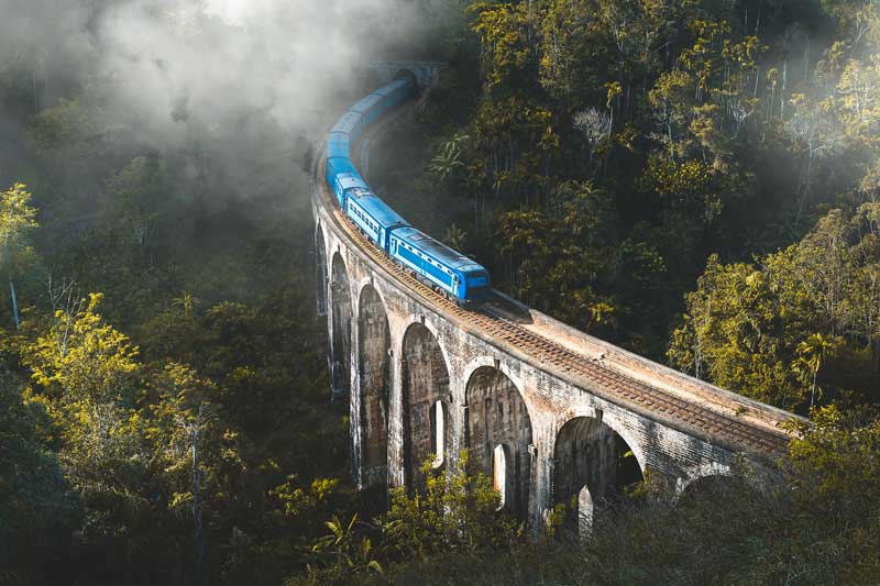
If you call it’s picturesque, it’s more likely a bane for the enticing mystical creation. Clouds hang low on a misty day, the famous Badulla train passes slowly across the bridge, it’s a divine feeling you have to grab yourself. It’s a paradise for photography maniacs and selfie lovers can add some unique captures for their travel diaries. When sun rays bounce off the mountains, a beautiful photograph of the bridge can enjoy its flamboyant shapes for the rest of life.
Nine Arch Bridge is an exclusive example of the architecture of colonial-era constructions, topper of attractions in Badulla district. When the British government redirected the steel allocated for the bridge, Sri Lankan engineers and builders completed it using stone blocks and cement. This huge tourist spot demonstrates how amazingly it can be fused engineering technology with the esthetic beauty of the environment. At present, it’s very much popular among foreigners and locals alike. Especially, amongst who came to catch a blush of the famous blue train comes across the rock bridge.
Nine Arches Bridge Location on the Map
Ravana Falls
It is another iconic waterfall in Badulla which is 82 feet in height. It is one of the best 3 tire waterfalls in Sri Lanka. We would not recommend you to hike up the rocky waterfall but why not have a dip in the basin right below the Ravana Falls.
Among the most Iconic places in the Badulla District Ravana falls is another place where you could enjoy the natural beauty in Sri Lanka. It’s not far away if you are planning to Visit Ella Rock or the Little Adams Peak. So, without wasting your time just jump on a bus or a Tuk Tuk and get directions to the Ravana falls.
It’s a 10 mins ride to reach this beautiful place in Ella. The waterfall flows in between the littles Adams Peak and the Ella Rock. The height of the water wall is around 82 feet which cascade down over an oval-shaped rock.
The Ravana Waterfall was named in memory of King Ravana who was once the most technologically advanced king based on historical Information. King Ravana hid Princess Sita in the Ravana Caves right Behind the Waterfall. This is based on prehistoric information and the Ramayana Story. It is believed that Princess Sita bathed in the Ravana Waterfall which was covered with thick dense forest back in the days.
Even though there are no warning signs you should not climb over the slippery surfaces. Yes, you can go for a dip in the basin right below the Ravana Falls. However, it might be dangerous to climb over the rocks. If you visit during a rainy season then you can easily see the waterfall flow in the shape of an Areca flower. But during the dry season the water flow will reduce dramatically.
This place is said to be one of the best for nature photography. Plus, you can find enough locals around the place if you are interested in knowing a bit more about the surroundings. The water in the Ravana Falls is crystal clear and they come from natural springs.
Locals and Tourists are strictly advised not to litter the place if they visit the Ravana Falls.
Ravana Falls Location on the Map
Ellewala Waterfall
Ellewala waterfall is a beatific small waterfall popular for its eco-liveliness and peaceful-countryside atmosphere hidden inside the territory of the Ella jungle. It’s not exactly similar to Ella falls, but, many people still manage to visit Ellewala falls to enjoy a bath, diving, or splash time in a natural pool in the midst of the jungle. It is also called chasing waterfall.
It’s about 4 meters’ height waterfall that is are accessible from Ella – Wellawaya road, at least five kilometers inside woods from Wellawaya town. When you are coming from Wellawaya, 3 km along the Ella road to reach an ancient temple, Rathmal Vehera. The opposite road from the temple directly leads to the falls.
If you are expecting to stay a couple of days in Ella, Ellewala falls an awesome place you should never miss. Except on the rainy days, it’s a well enjoyable, safe natural pool you can have some relaxation in your busy schedule. It’s a precaution because on rainy days the water level in Ellewala falls can be dramatically increased. And finding help at a center of a jungle would not be that easy. There is an awesome cyclic trek, one of the most adventurous cycling trek in Sri Lanka. it’s almost spattered downhill and you have to ride uphill by a vehicle. Amongst the ride, it gives rider lifetime memories of Sri Lankan villages, paddy fields, waterways, and epic views of amazing landscapes.
Ellewala Waterfall Location on the Map
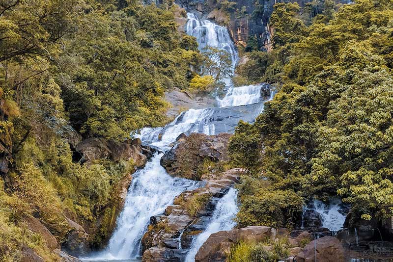
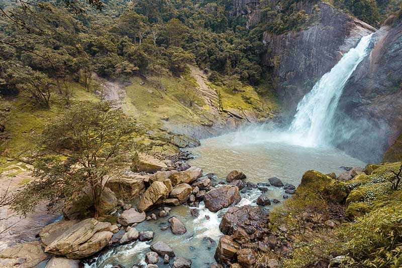
Diyaluma Falls
It is the second-highest waterfall in Sri Lanka which is 220m (720 feet) high located near Koslanda. If you reach the top of the Diyaluma falls (Upper Diyaluma) then you will be able to go for a swim in the natural pools. Keep an eye on the rising water levels during the rainy season in this area.
Yes, you are right you came here to read about the second-highest waterfall in the island of Sri Lanka. Diyaluma is one of the best iconic waterfalls in the country which is located in Koslanda that belongs to the Badulla District. The meaning of Diyaluma stands for the rapid flow of water downstream. The waterfall is 220m (720 feet) high and it laster turned in to Punagala Oya which is a branch of the Kuda Oya that then joins the Kirinndi Oya.
If you are planning to start your journey from Colombo then the best thing you can do is to Jump on the Badulla Night Mail Train which will start at 8.15 PM from Colombo and the Trail will reach Haputale by 6.30 am in the morning. There are plenty of Coffee sellers for you to warm you up in the cold weather conditions on your journey to Haputale.
So, the journey begins from Haputale on a bus to Wellawaya and you will have to get down at Koslanda Junction. Next, hire a tuk-tuk to the Diyaluma falls. Or you can simply hire a rent a car for the whole journey. The best part is that you can ask the tuk-tuk drivers to take you to watch the elephants who come to drink water from the upper deck of the Diyaluma falls.
Tuk-tuk drivers will drop you at the Poonagala estate where you will have to go through a trek. The estate is famous for its rubber and the breath-taking view is one of a kind. And you will surely enjoy the journey to the falls even though you find some rocky places on the way. Once you continue the journey for about 45 minutes you will reach the Upper Diyaluma.
You can find some natural water basins on top of the Upper Deck of Diyaluma falls but keep an eye on the rising water levels during the rainy season.
Diyaluma Falls Location on the Map
Upper Diyaluma Waterfall
Are you thinking of a full day adventure amongst the tour in Badulla? If you hope so, the 2nd highest waterfall in Sri Lanka is ready to fulfill your exploiting thirst by a super exciting travel adventure mixed up with the grace of nature. The dense jungle and beautiful landscaping are enthralling here you can have an epic view of one of the best natural water pools in the world. Diyaluma is consists of multiple waterfalls, which also has some beautiful pools created amidst.
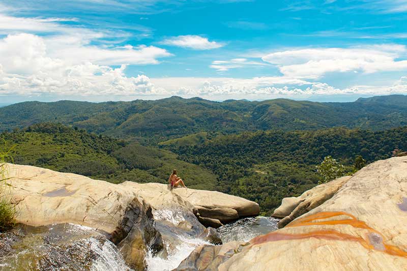
Upper Diyaluma is somewhere you can have trekked down through a ten-minute short hike to the hill from the Diyaluma falls. The stunning view of mountains and lush greens would make you spellbound for a few seconds. The series of the water pools flows together and prolapse from the edge into another large pool before collapsing through the precipice. The enchanting massive pool is located 628 feet down from the edge of the last pool creating the amazing Diyaluma waterfall. It’s hard to have a look down from the crest. But, if you are brave, there is a chance of peer over the cliff and look over the giant waterfalls down.
You also can watch the sunset through the top of the waterfall, fly your drone, snap some incredible shots, and relax over the valley while feeling the aesthetic beauty of nature. Once you visited Diyaluma you won’t ever hesitate to recommend your friend again.
Upper Diyaluma Waterfall Location on the Map
Lipton’s Seat
Once the great tea planter Sir Thomas Lipton used to sit and observe his pride from the Lipton Seat. You can easily observe the Dambatenna tea estate and as far as Hambantota Harbor in the Southern Coastal belt from Lipton Seat. Try to visit the point of observation in the morning to get the best view.
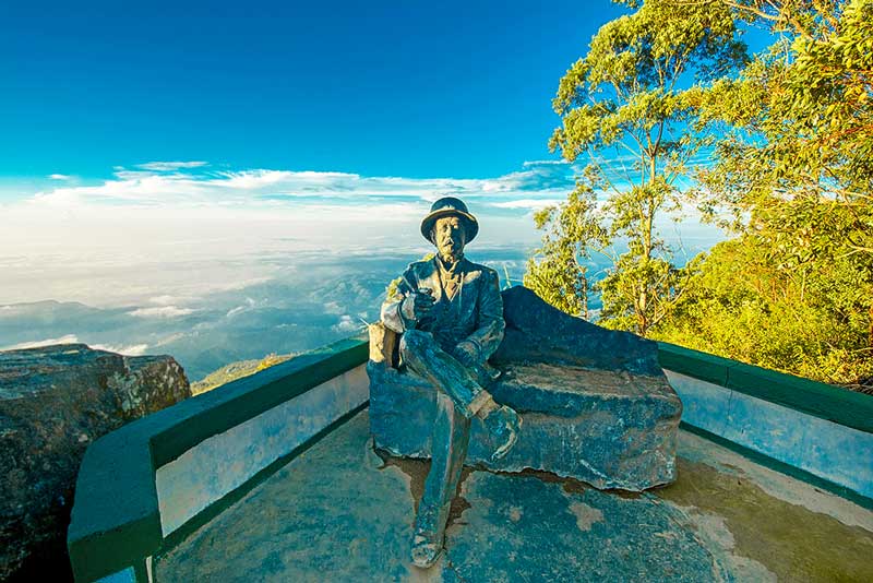
It is one of the best-elevated viewpoints in Sri Lanka situated along the Haputale road in the Badulla District. Lipton Seat is in the Dambatenna tea factory. You will be able to observe a breath-taking view from the Lipton’s Seat where once the great tea planter Sir Thomas Lipton used to observe his plantation.
It’s a journey of around 7 km through the beautiful tea estate of Dambatenna to reach Lipton Seat or you can come through Nayabedda estate in Bandarawela. There are plenty of signs which will help you to reach the point of the Lipton Seat. In some parts of the route you will be able to observe the original paving stones that were used during the British time period to construct the road. The journey to the place will be roughly around 2 to 3 hours but it will not be a tiring journey to reach the point of observation.
Once you reach the famous Lipton Seat then you will be able to view Sabaragamuwa, Uva, Central and Eastern provinces where you can easily view them from the point of observation. In addition to that Udawalawe Lake, Chandrika Lake and the Handapangala Lake can be observed on a clear day when there is no mist surrounding the mountain ranges. Moreover, you will be able to observe the Hambantota Harbor in the southern coastal belt.
If you are visiting Lipton Seat from the Nayabedda Estate then you will be able to witness the Bandarawela City from Catherine’s Seat. Lemathota waterfall is also another wonderful site for the visitors if you select the Dambatenna route to Visit Lipton Seat. The route from Dambatenna is not quite famous but it will be a great opportunity for you to experience the rich biodiversity with a variety of fauna and flora.
The best time to visit Lipton Seat is said to be the morning hours so try your best to reach the observation point from 8.00 am to 11.00 am.
Lipton’s Seat Location on the Map
Adisham Bungalow
Sir Thomas Lister Villiers an English planter who worked at the George Stuarts Tea Industry built the Adisham Bungalow in 1931. Now the Monastery is owned by the Benedictine Monks. At the bungalow make sure to taste the Jam and the Cordial made in the orchards of the Adisham Bungalow.
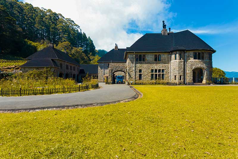
It is one of the best British Colonial Houses that is well preserved up to date, situated near Haputhale in the Badulla District. The history of the Adisham Monastery goes way back to the time period between 1928 to 1948. Currently, the Adisham Monastery is owned by the Benedictine Monks and it is opened for the public only on the weekends, public and school holidays.
The scenic beauty will make you fall in love with the beautiful monastery surrounded by the flower beds and the orchards with a variety of fruits and vegetables. Towards the side of the monastery is a thick dense forest with a bird sanctuary called Thangamale Sanctuary. The Bungalow will be opened from 9.00 am to 4.00 pm. However, to embrace the beauty of the monastery and the weather, its better you visit the place early in the morning.
Sir Thomas Lister Villiers an English planter came to Sri Lanka in a ship that transport Tea in 1827. As a young lad, he was working at the George Stuarts Tea Industry when he commenced building the Adisham bungalow in 1931. Once Sir Thomas Lister Villiers retired from service the ownership of the Adisham Bungalow was taken over by the Sedawatte mills in 1951. Again in 1961 Roman Catholic Church purchased the bungalow in 1961 which converted the Bungalow into a Monastery.
There are many Orchards around the Adisham Monastery maintained by the Benedictine Monks. With the helping hand of the villages around the monastery the monks have cultivated Oranges, Guavas, Strawberries and Vegetables.
The locals and the tourist who come to visit the Monastery can purchase Jam, Chutney and different types of Cordials made in the Monastery. There are 100% natural and no artificial adhesives have been used in the preparation of these products. The income from these organic products are used to maintain the Bungalow. However, if you forget to purchase these products then you can purchase them from the Sacred Heart Church in Rajagiriya, Colombo.
Adisham Bungalow Location on the Map
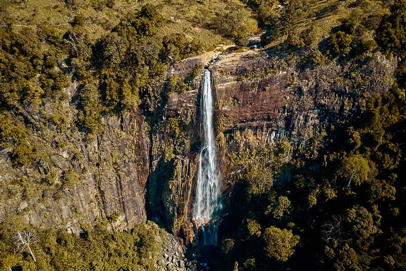
Bambarakanda Falls
It is the tallest waterfall in Sri Lanka which flows through the mountain range of Kalupahana. The height of the waterfall is approximately 863 feet and it is ranked as the 299th tallest waterfall in the world. Bambarakanda Falls is a branch of Kuda Oya which later joins the Walawe River.
Bambarakanda Falls is the tallest waterfall in Sri Lanka which flows through the mountain range of Kalupahana. The height of the waterfall is approximately 863 feet situated in the Badulla District. It is the 299th world tallest waterfall. Bambarakanda Falls is a branch of Kuda Oya which later joins the Walawe River.
There are many ways that you can use to reach the Bambarakanda waterfall. The best way is to take the Balangoda to Badulla Route. This is also known as the A4 Highway that leads to Kalupahana Junction. Then follow the signboards along the road for at least 3.5 km or you can try out with a vehicle that has good ground clearance. The road to Bambarakanda Falls is quite narrow and the road has not been renovated. Therefore, the best way is to travel by foot.
Bambarakanda Falls is one of the best places for photography and hikers. There is a trail that will lead to the upper deck of the waterfall. There is a large basin on the top of the fall, which is connected with the waterfall. Even though it looks safe there might be a sudden rise in the water level. Therefore, the tourist and the locals are to keep an eye on the rising water levels. The best months to visit the beautiful waterfall is from March to May when the water levels are low. And it is very dangerous to go near the waterfall between the months of November and February with the heavy rainfall in the hill country.
If you are planning to hike up the waterfall, then make sure that you gear up for the journey. There are leaches in this area which are blood-sucking insects but harmless. With a bit of lime-based solution or concentrated salt solution, you will be able to easily get rid of them.
Also do not forget to visit Lanka Ella falls a hidden waterfall near Bamabrakanda falls. You can take the trail near the bottom of the Bamabrakanda to reach this hidden beauty.
Bambarakanda Falls Location on the Map
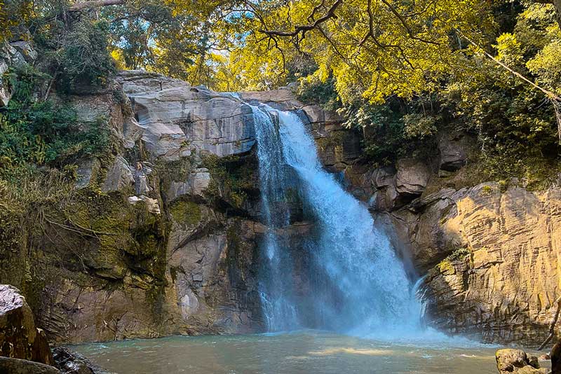
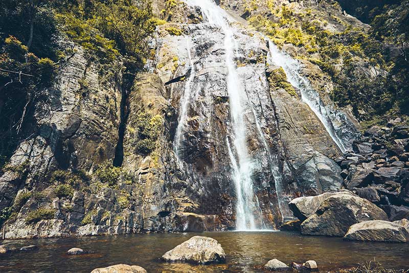
Dunhinda Falls
5 km off the Badulla town you will be able to reach the entrance of Dunhinda falls. Dunhinda Falls is around 210 feet high and it is also known as the Bridal Falls as it flows down in the shape of a veil of a Bride. There is a footpath on the side of the waterfall that will lead to the upper deck of the falls.
Dunhinda Falls is another picturesque waterfall that is located 5km off the Badulla Town. The name Dunhinda was given to the waterfall due to the mist that is created by the water stream that flows downwards from the falls. The height of the Dunhinda Falls is around 210 feet. And it is also known as the Bridal Falls as it flows down in the shape of a veil of a Bride. The waterfall flows and joins the Badulu Oya which flows through the Badulla town. There will be a fee for both the locals and the tourist to visit the Dunhinda Falls.
If you are starting your journey from Colombo then the best thing that you can do is to book the Badulla Colombo Night mail train starting from Colombo Fort Station at 8.15 pm. Then throughout the night, the train will slowly rumble to a halt in Badulla around 6.30 am in the morning. You might experience freezing weather conditions. So, don’t forget to sip a hot coffee from a seller on the train.
At 6.30 in the morning you might not find a bus, therefore its better you know how much time it will take you to travel to Dunhinda from Badulla town. If you plan to walk from Badulla to Dunhinda falls you can use Mahiyangana Road which will take you 45 mins to reach Dunhinda. By means of a vehicle, it will take around 15 mins to reach Dunhinda. Else if you plan to hire a bicycle then it will take around 20-30 minutes to reach the Dunhinda falls.
Make sure that you take your camera gear with you to experience the beauty of this wonderful waterfall. It is also a great spot for you to go for a dip if you are planning to visit other places too.
Dunhinda Falls Location on the Map
Muthiyangana Temple
It is one of the 16 sacred places in Sri Lanka. The Muthiyanganaya Stupa is 65 feet tall and the diameter is around 270 feet. Muthiyanganaya Raja Maha Viharaya Stupa was erected by enshrining the relics of Load Buddha which includes Mukthaka Dathu and Kesha Dathu by King Indaka.
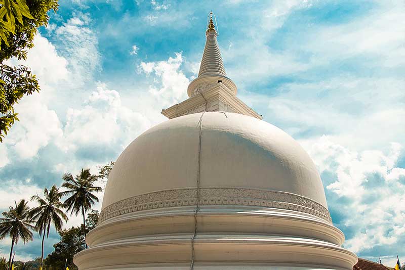
It is one of the 16 sacred places in Sri Lanka for the Buddhist devotees situated in the Middle of the Badulla Town in Uva Province. It’s not that hard to find the place since you can easily access the Muthiyanganaya Temple by means of bus, tuk-tuk or even by train. This is if you are traveling from Colombo. If you are traveling to Ella you can easily reach the temple which is 20 km away from Ella Rock. The Muthiyanganaya Stupa is 65 feet tall and the diameter is around 270 feet.
History of Muthiyangaya Temple
Load Buddha visited Sri Lanka for the 3rd time with 500 other Arahants as an invitation by the Naga king Maniakkhitha. Then the ruler of the Namunukula Mountain Rage King Indaka invited Load Buddha to visit Badulla. Muthiyanganaya Raja Maha Viharaya Stupa was erected by enshrining the relics of the Load Buddha. This includes Mukthaka Dathu (sweat turned in to pearls) and Kesha Dathu (Hair) by King Indaka. Since then from generation to generation many leaders who ruled the country have reconstructed and renovated the Sacred Muthiyanganaya Temple.
The Temple is also famous for the Dragon Pandol which is also known as the Makara Thorana built in an unverified Era. In addition to that the Archeologists say that there were seven Bo trees at the Temple. However, three of them had vanished with time. The four of the remaining Bo trees are found in the temple. King Devanam Piyatissa has planted the very last Bo Tree at the Muthiyanganaya Temple.
Most of the devotees visit the Muthiyanganaya temple on Poya days. It is best to wear white. Also, make sure that all your clothes are covering your body as a way of paying respect to this sacred place in Badulla.
Muthiyangana Temple Location on the Map
Madulsima – Pitamaruwa Mini Worlds End
Towards the end of the Roeberry Estate Plantation where the footpath ends you will experience a sudden drop of 1250 feet. You can observe Kandy, Meegahakiula, Mahiyanganaya, Ampara, Senanayaka reservoir, Monaragala, Passara and Badulla with the directions marked on the plate.
Isolated and neglected but it is the second-best Worlds End in Sri Lanka. You can visit the end of the Roeberry estate plantation where the footpath ends to a sudden drop of 1250 feet. The Worlds End in Hortain Plains is 870 m (2,854 feet). Therefore, you can do the math to do a size comparison of the Madulsima – Pitamaruwa Mini Worlds End.
Once you reach the Passara town then take a turn to the left to the Pitamaruwa Road and you will reach the Passara – Madulsima Road. Reach Elamanna after a journey of around 30 km. And you will come across a place called the Kokagala area. Then, follow the signs. Once you reach the Summer hut a small footpath will be there which will lead you to the Madulsima – Pitamaruwa Mini Worlds End.
The other pathway will lead to the D.S ROCK which was named in memory of Mr. D.S Senanayake.
There are a couple of summer huts on the way and you can take a short break if you feel exhausted in your journey to reach the World’s End. It is one of a kind breaths taking views. And you might feel that you are given wings to look down at the beauty of the land over the clouds. Tourists and the locals are advised not to look down the abyss. Because sudden gush of wind might push you down the world’s end to an endless journey in your life. So be cautious when you try to observe from the viewpoint of Madulsima – Pitamaruwa Mini Worlds End.
Once you reach the Madulsima – Pitamuruwa World’s End you will be able to see Kandy, Meegahakiula, Mahiyanganaya, Ampara, Senanayaka reservoir, Monaragala, Passara and Badulla. The directions marked on the plate will make it easy to find different cities. On your way to the World’s End you will be able to visit Metigahatenna falls, which is located close to Ekiriya. There will be no entrance tickets. Therefore, this will be a great opportunity for you to observe the beauty of the island from the viewpoint of Madulsima – Pitamaruwa Mini Worlds End.
Madulsima – Pitamaruwa Mini World’s End Location on the Map
Mahiyangana Temple
Mahiyangana Raja Maha Viharaya occupies a significant role in the Buddhist history of Sri Lanka. As history says, the lord Buddha made his first visit to Sri Lanka after 9 months of enlightenment. Lord Buddha had foreseen that Buddhism lasts five thousand years in Sri Lanka. Therefore, he managed the visit for purpose of consecrate Sri Lankan earth from some egregious spirits that caused deadly diseases to innocent people living in Sri Lanka. Among that journey, Mahiyangana stupa was created by Yakkas dedicating to the service he has done.
After the great demise of lord Buddha in India, an arahant thera has recovered the funeral pyre from where the lord Buddha cremated. That ash has also brought to Sri Lanka and again enshrined in the Mahiyangana stupa and aggrandize up to 18 feet. Centuries later, king Dutugamunu again renovated the ruined stupa after the war against Tamil king, Elara which has been situated in the territory of the dead king. After that king, Voharaka Thissa and king Sangabhodhi had taken many protective measures for the Mahiyangana Vihara and so on.
Recently, former prime minister Hon. D.S. Senanayaka reconstructed the stupa and in 1961, crystal-cut gems were adorned to the dome of the stupa. It was a gift from the Myanmar government which was ceremonially opened amidst hundreds of devotees in witness. If you are travel around Sri Lanka it will be a great experience this religious wonder including in your itinerary.
Mahiyangana Temple Location on the Map
Sorabora Lake
Sorabora lake (Horabora Wewa) located in Mahiyanganaya, Sri Lanka believed to be built in the 2nd century BC. It’s a huge and one of the most ancient reservoirs made by human hands. It’s created using 100% indigenous methods by controlling water flow along with maintaining the beautiful natural surroundings. The lush green foliage with fauna and flora adds the place a unique beauty its own. Sorabora lake is a consummate area for enjoying a slice of a paradise of natural bliss.
According to chronicles, this lake is created by a Giant called Bulatha and his wife who lived in the era of King Dutugamunu. The giant was ruled to supply betel leaves to the King daily. Meanwhile, on his journey to the palace and home, he observed a water stream between two hills. Then decided to create a lake and provide water to people in that area. The lake had been ceremonially opened by King Dutugamunu as invited by the giant. Then the king has appointed the giant as one of his general due to the selfless act he had done.
The ancient irrigation technology used in Sorabora lake is still functioning even today. The large embankment of the lake is 40 feet high 11 feet wide and stretchable up to 500 meters. Regarding the world technology in that era, it’s incredible to co-operate the natural obstacles while constructing a lake. Fused with the expanded banausic beauty along with proper irrigating techniques this lake is bizarre to the whole engineering system.
Sorabora Lake Location on the Map
Other important tourist places that you can visit along with Badulla
Bogoda Ancient Wooden Bridge
Uva Halpewatte Tea Factory
Demodara Railway Station
Dhowa Rock Temple
Buduruwagala Temple
Dambana Veddha Village (Dambana Wedi Gammanaya)
Rathna Ella Fall
Maduru Oya National Park
Maha Oya Hot Water Springs
Dambetenna Tea factory
Narangala Mountain
Dutch Fort